

Wednesday, August 31, 2005
Hurricane Party Over, but Hangover Persists
Steve Scolnik @ 3:50 PM
5:15 update: T.D. 13 is now Tropical Storm Lee, but is still no threat to land.
After a very sultry night, dewpoints in the upper 60s and a strong breeze gusting over 25 mph at times have made today more comfortable in the Washington DC metro area. Last night's low of 80 will undoubtedly be eclipsed before midnight, but if it were to hold, it would make today's minimum the warmest of the summer. Despite some ominous-looking clouds swirling around the large circulation from the remnants of Katrina, the nearest precipitation to the Washington area is widely scattered across Pennsylvania.
Outlook
Clouds, winds, and humidity will all decrease overnight, with lows by morning in the upper 60s to around 70. Tomorrow will kick off the first day of meteorological fall with partly cloudy skies, lower humidity, and warm temperatures, highs in the mid 80s.
Tropical Topics
The remnants of Katrina are still being tracked for flood potential as they merge into an extratropical low pressure area to the northeast. Maximum precipitation this morning was near the U.S.-Canadian border in New York state.
Tropical Depression 13 has regenerated between Bermuda and the Azores. It is no threat to land as it moves northeast.
The low pressure area which is now about 1300 miles east of the Lesser Antilles is well organized and shows potential for development as it moves northwest in the next couple of days.
Katrina Kuestions
The history of the master disaster called Katrina is far from being written, but it's not too early to start asking what lessons can be learned from the experience. The first question to be asked, and the most objective to answer, is:
How good was the science?
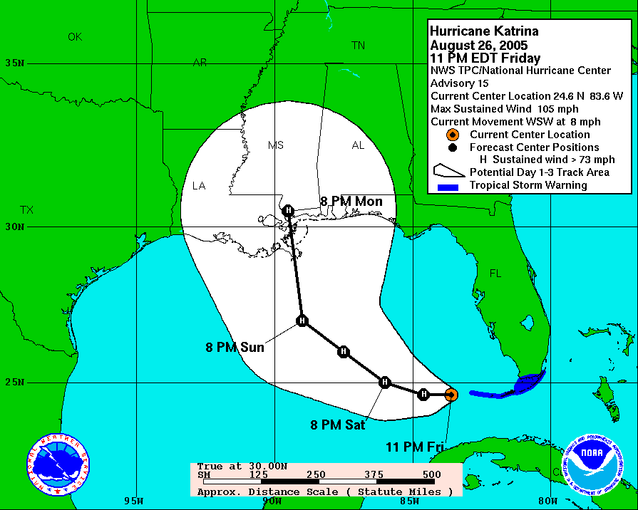
Answer: In a word, outstanding. Director Max Mayfield and his crew at the National Hurricane Center can be justifiably proud of the accuracy of their forecasts. The forecast track issued 11pm Friday, about 60 hours before Gulf landfall, had an error of about 15 nautical miles. (The full sequence of forecast tracks is available here).
The second question is:
How good was the emergency preparation?
This one will certainly be hotly debated, but my opinion so far is, not so good. Given the clear threat to New Orleans as early as Friday night and the long lead time required for an effective evacuation, why was the evacuation order delayed until nearly noon on Sunday?
There are a whole series of additional questions related to the effectiveness of the response which are still to be resolved and which we don't have time to cover today. Ultimately, however, they boil down to: Which is more effective, listening to the science and putting plans in place, with adequate funding, to deal with the inevitable, or buzzing the ruins in a 747 with a look of studied concern and offering prayers for the certainly hundreds, probably thousands, of casualties?
After a very sultry night, dewpoints in the upper 60s and a strong breeze gusting over 25 mph at times have made today more comfortable in the Washington DC metro area. Last night's low of 80 will undoubtedly be eclipsed before midnight, but if it were to hold, it would make today's minimum the warmest of the summer. Despite some ominous-looking clouds swirling around the large circulation from the remnants of Katrina, the nearest precipitation to the Washington area is widely scattered across Pennsylvania.
Outlook
Clouds, winds, and humidity will all decrease overnight, with lows by morning in the upper 60s to around 70. Tomorrow will kick off the first day of meteorological fall with partly cloudy skies, lower humidity, and warm temperatures, highs in the mid 80s.
Tropical Topics
The remnants of Katrina are still being tracked for flood potential as they merge into an extratropical low pressure area to the northeast. Maximum precipitation this morning was near the U.S.-Canadian border in New York state.
Tropical Depression 13 has regenerated between Bermuda and the Azores. It is no threat to land as it moves northeast.
The low pressure area which is now about 1300 miles east of the Lesser Antilles is well organized and shows potential for development as it moves northwest in the next couple of days.
Katrina Kuestions
The history of the master disaster called Katrina is far from being written, but it's not too early to start asking what lessons can be learned from the experience. The first question to be asked, and the most objective to answer, is:
How good was the science?
Answer: In a word, outstanding. Director Max Mayfield and his crew at the National Hurricane Center can be justifiably proud of the accuracy of their forecasts. The forecast track issued 11pm Friday, about 60 hours before Gulf landfall, had an error of about 15 nautical miles. (The full sequence of forecast tracks is available here).
The second question is:
How good was the emergency preparation?
This one will certainly be hotly debated, but my opinion so far is, not so good. Given the clear threat to New Orleans as early as Friday night and the long lead time required for an effective evacuation, why was the evacuation order delayed until nearly noon on Sunday?
There are a whole series of additional questions related to the effectiveness of the response which are still to be resolved and which we don't have time to cover today. Ultimately, however, they boil down to: Which is more effective, listening to the science and putting plans in place, with adequate funding, to deal with the inevitable, or buzzing the ruins in a 747 with a look of studied concern and offering prayers for the certainly hundreds, probably thousands, of casualties?
Comments are closed for this archived entry | Link |  Email this post
Email this post
