

Friday, September 02, 2005
Saturday forecast, and Katrina Notes
Jason Samenow @ 11:40 PM
Expect clear skies with temperatures in falling from about 79 to 71 during the game. Score prediction: Navy 13, Maryland 10
Clear skies with temperatures dropping from 80 to 70 during the game. Score prediction: Virginia 35, Western Michigan 17
Katrina Notes
- On Thursday I wrote an editorial calling for a Congressional investigation into the Katrina response. It appears this is already coming to fruition. The Associated Press reports "two key U.S. senators . . . will open a bipartisan investigation into what they described as an "immense failure" of the government response to the victims of Hurricane Katrina."
- I thought Steve wrote a very insightful essay in his afternoon post yesterday here at CapitalWeather.com. If you missed it, here's the direct link (or scroll down one post and read the bit with the subheading "More Thoughts on Katrina").
- According to AccuWeather: "This hurricane will be remembered as the worst natural disaster in our nation's history taking away top billing from the likes of the Galveston Hurricane, the San Francisco Earthquake and the eruption of Mount St. Helens." Compare this to what I wrote on this blog exactly one week ago: "if New Orleans gets a direct hit from a Category 4 or higher storm (and Katrina may reach these levels), the potential is there for one of the worst weather catastrophes or catastrophes of any sort on U.S. soil in decades."
- A friend of mine, who evacuated New Orleans for Florida one week ago today, likened FEMA Chief Mike Brown to the (ex) Iraqi (mis)information minister (who said "we will beat the infidels have no fear" at the same time American tanks could be seen down the street). This CNN article lends some credibility to that characterization.
- WxNation.com's Wire continues to provide updates and a nice set of links related to Katrina, including to some of the key charities (President Bush suggested the Red Cross and Salvation Army) if you would like to help.
- Washington Post article: Slogging, and Blogging, Through Katrina
I'm not going to write a detailed critique of the media coverage of Katrina, but I do have a few comments. In my opinion, CNN has outclassed its competition. FOX News and MSNBC have done some good things, but just haven't been as consistently strong. I have no patience for The Weather Channel's format that is hampered by "local on the eights" and constant commercial interruptions during breaking news. Furthermore, as a weather outlet, they just don't have the expertise covering news and, surprisingly, their weather coverage has not stood out. CNN and Fox News have leveled the playing field on weather during hurricanes by either having strong in-house talent (CNN's Rob Marciano and Chad Myers) or interviewing outside experts (e.g. National Hurricane Center experts and AccuWeather's Joe Bastardi).
 Email this post
Dial "M" for Maria
Steve Scolnik @ 3:50 PM
Outlook
Tonight, the passage of the cold front should allow temperatures to drop a few degrees below last night: mid 60s in town, and low 60s in the 'burbs. Tomorrow will be warm and dry, highs in the mid 80s. Scroll down for Jason's full weekend forecast and tune in each morning for event updates. Have a great holiday!
Tropical Topics
This year's hectic hurricane season continues apace. (I've always wanted to use that word.) Former Storm Lee continues to be depressed in the central Atlantic, and advisories were discontinued at 11pm last night unless regeneration occurs.
Tropical Storm Maria developed from T.D. 14 this morning. Fortunately for the recovery efforts from the Katrina Catastrophe, this storm is no threat to land. It is projected to move northwestward east of Bermuda next week.
In the 55 years since storms began having names, there have been only 9 years with an "M" storm, and the only other one as early as September was Marilyn, on 9/12/1995. Even in the record-breaking year of 1933, what would have been the "M" storm occurred on September 8.
More Thoughts on Katrina
As some readers are fond of reminding us, this is a DC weather blog, and strictly speaking, Katrina was not a DC weather event. DC is where environmental policies are formulated and funded, however, and the extent of the tragedy is relevant whether we have direct personal connections to the Gulf Coast or not. A front page article"Planning, Response Are Faulted" and an editorial"From Bad to Worse" in today's WaPo address questions which had already been raised in Capitalweather posts and comments as early as before storm landfall. New Orleans mayor Nagin has been widely quoted strongly expressing his opinion.
It's extremely important to have this discussion now, even as people are still being rescued and bodies are being recovered. That's because long, sad history proves that it's impossible to engage the public on a problem until a crisis actually occurs. The problem with the environmental crisis that we face is that it is mostly gradual in its effects. There have already been "canaries" dying in the coal mine, but this is one 800-pound gorilla. Someone said on NPR, I can't recall who, that the real test of a society is not how it reacts to a crisis at the time, but how it deals with the lessons afterward. We have to decide as a country and as members of a larger world community whether we have the will to set the necessary priorities to have a sustainable civilization, or whether the purpose of life is simply to consume resources at the maximum possible rate. Should we cut $70 million from hurricane protection for New Orleans, but spend $223 million for a bridge in Alaska to an island with 50 residents? That kind of action, although carried out in the genteel halls of Congress, is simply looting without a shopping bag.
There are many questions which need to be addressed in this particular situation, not the least of which is, should we make a huge investment, only to restore New Orleans to its previous level of risk? Asking these questions is not partisanship, it is humanitarianism. Partisanship is putting ideology above science, expertise, and professionalism. Partisanship is substituting photo ops for action. For the record, in case anyone is not aware, although the national administration is obviously Republican, both the state and local administrations in New Orleans are Democratic. There is clearly plenty of responsibility to go around. Our responsibility, as scientists and educated members of the concerned public, is to keep asking the questions. For too long, the discussions have been carried out in the polite forums of academic debate, where they can be conveniently ignored by those who have a vested interest in business as usual. The results are in: The policy of business as usual is bankrupt, and it must be replaced.
Your constructive comments are welcome.
Email this post
Weekend forecast and continuing Katrina coverage
Jason Samenow @ 12:00 AM
A BIG dome of Canadian high pressure will slowly build in over the next several days bringing an outstanding stretch of weather beginning now and extending through the holiday weekend. The high today will be in the upper 80s, with comfortable humidity levels. As the center of the cool high pressure area moves closer to us, maximum temperatures will drop a bit -- with afternoon temperatures reaching the low 80s Saturday through Monday. Overnight lows will fall into the mid 60s downtown and to near 60 (or a bit lower) in the cooler suburbs.
Check back each morning during the weekend for forecasts for specific outdoor events, including college football games.
Katrina Editorial Follow-up on Why Weren't Prepared
In my editorial yesterday, I wrote it was too early to point fingers, but that a Congressional commission should be established to investigate the failures in mitigating the threat of, preparing for and responding to this disaster in light of the fact many saw it coming for a long time.
In particular, the failure of decisionmakers to exercise the precautionary principle in preventing this catastrophe will be a big story in the coming days, weeks and months. Already, the mainstream media are raising the issue. Aaron Brown touched on it on CNN last night and in his story Politicians Failed Storm Victims, Associated Press correspondent Ron Fournier (of the White House press corps) wrote:
...all the finger-pointing misses the point: Politicians and the people they lead too often ignore danger signs until a crisis hits.This assessment is probably true to an extent, but perhaps somewhat of an oversimplification of why the preparations/actions of decisionmakers were insufficient (or absent). The following excerpt offers a more sophisticated explanation:
Source: Is Hurricane Katrina a Natural Disaster or a Crisis in Public Policy? (from essay posted on TheSabre.com "Corner" message board, written by an individual who was a research assistant and independent contractor for the Center For Hazards Assessment Response Technologies at the University of New Orleans from 2001-03).The break in the levees that has led to the inundation of the New Orleans area constitutes more than an engineering failure. It signifies a failure of our governing institutions to represent and serve the public interest; it represents a failure in the promises of economic development to improve the quality of life in our communities. On the national level, I think it reveals a poverty of the American imagination, which refuses to dream of workable solutions to our real ecological problems, and which is mindlessly forced to seek salvation through the ostensibly free market and the promise of growth. It is impossible to say if even the most revolutionary thinking in planning and environmental management could have quelled the destruction of Katrina, but it is certain that business as usual guaranteed it.
Animated satellite image of Katrina
The image that follows shows Katrina as she crosses southern Florida, emerges in the Gulf, intensifies and strikes southeast Louisiana: Satellite loop (Requires Quicktime)
Ninety Degree Forecast Contest -- Congratulations to Jason Jones, Winner
CapitalWeather.com visitor Jason Jones is the winner of our summer 90 degree forecast contest. He correctly predicted there would be thirty-two 90 degree days, and was just 1 degree off in his forecast for the summer's hottest temperature (he said 98, it was 97). Jason beat out 49 other contestants and will receive his Midland Weather Radio in the mail. Thanks to everyone for participating.
Email this post
Thursday, September 01, 2005
Quick Update
Steve Scolnik @ 3:50 PM
- Official temperature reached 87 at 4:00; 90 is possible tomorrow, but with decent humidity. Turn off your air conditioning tonight for lows in the 60s!
- Holiday weekend continues to look great.
- Lee regressed to a depression, moving north well east of Bermuda.
- T.D. 14 formed this morning in the central Atlantic, expected to move east of Bermuda early next week.
- NPR has more Katrina resource links
Email this post
Editorial-- Katrina's toll: Can/should fingers be pointed?
Jason Samenow @ 11:00 AM
Some will say it's easy to be a Monday morning quarterback, and it's not the time to be second guessing officials on all that has transpired. I don't dispute that. However, I do think that once the flood waters have receded and the devastation assessed, a thorough investigation should be initiated by Congress to evaluate the adequacy of the preparation and response to Katrina.
The potential catastrophic impact of a major hurricane on New Orleans has been well-understood for years. Academics, public officials, meteorologists and emergency managers have all known certain scenarios represented a clear and present danger to the area. Popular Mechanics published an article on 9/11/01 (ironically) about the threat, National Geographic ran a story on this in the last year and New Orleans Times-Picayune recently published an extensive feature entitled "Washing Away". Louisiana State University established an entire institute on the public health impacts of hurricanes and focused much of their research on the New Orleans area. In January of this year, PBS's NOVA airred a feature on hurricanes and New Orleans. And, as I mentioned in Saturday's post, I attended a Congressional seminar just this past June in which Louisiana Senator Mary Landrieu spoke of the vulnerability of the region and professors documented the dire threat hurricanes posed.
It had been well-established that a worst case scenario could kill tens of thousands of people. Of course, what has occurred in the last week has been horrific beyond words, but it was not the worst case scenario. Statistically, the realization of a worst case scenario (which would've involved New Orleans being on the east side of the eyewall instead of the west in a Category 5 storm as opposed to a Category 4) was (is) a very low probability event. But something slightly less than a worst case scenario was NOT a low probability event. For example, a Category 2 or 3 hurricane that was slower moving and/or moved just west of the city may have caused similar damage and loss of life. In fact, there are any number of scenarios that probably would've resulted in calamity. And I think a lot of people recognized this.
As so many influential people were armed with this information, it begs the question why more wasn't done to mitigate the potential impact and respond more expeditously. It's fair to ask this question just as it was fair to ask the President and intelligence community why more resources weren't expended to eliminate Usama Bin Laden pre 9/11. I would argue a major hurricane striking in the vicinity New Orleans was a more transparent threat to life and property than airplanes flying into skyscrapers. Accordingly, just as the 9/11 Commission was established, a Hurricane Katrina Commission will, undoubtedly, be in order.
Comments welcome
Email this post
Wednesday, August 31, 2005
10-Day Outlook: Tranquil Weather Returns
Josh Larson @ 11:00 PM
Today's forecast calls for mostly sunny and breezy conditions with much more comfortable humidity levels (dew points near 60). Temperatures will reach the upper 80s in most locations. Expect mostly clear and comfortable weather tonight, with lows in the mid 60s downtown, slightly cooler across the suburbs.
Quick Pattern Overview
In the wake of Katrina, we will see high pressure building into the mid-Atlantic and Northeast behind a frontal system which passed through the region yesterday and lowered humidity levels. We will generally hold onto a weak mean trough generally positioned over the Eastern US, allowing for air aloft to enter our region from the west or northwest instead of the more humid (and warmer) south or southwest. There is little indication of an organized precipitation outbreak for our region over the period. We should continue to watch the Tropics over the next ten days as atmospheric and oceanic patterns that are conducive to tropical development will linger.
The next 5 days (Sept 1-5)
Forecast high/low: 84/62 (normal = 83/66)
Forecast precip: below normal
After today's mostly sunny and warm, though noticeably less humid, weather, Friday will feature almost carbon copy conditions. Expect abundant sunshine, comfortable humidity levels and temperatures near 89/64. The long holiday weekend looks absolutely terrific, with the continuation of abundant sunshine and pleasant humidity levels, and the added bonus of cooler temperatures: expect temperatures Saturday near 84/61, with temperatures on Sunday near 80/59. (Expect crisp overnight lows in the lower to middle 50s across the cooler suburbs over the weekend.) Labor Day Monday looks to be a picture-perfect weather day, with seasonably cool temperatures and mostly sunny skies. Expect temperatures near 77/59 downtown, with cooler overnight lows in the suburbs.
The following 5 days (Sept 6-10)
Forecast high/low: 80/62 (normal = 82/64)
Forecast precip: below normal
Global long-range models suggest a continuation of tranquil, dry, very comfortable weather extending into most of next week. As such, the forecast for the following 5 days is quite simple: Expect most days to feature mostly sunny skies (with mostly clear nights), with little or no chances for precipitation. Highs during this period will likely range from the upper 70s to the lower 80s, with overnight lows from the upper 50s to the lower 60s downtown (though once again cooler across the suburbs). Enjoy!
Verification of Last Week's Outlook
Mixed is the best way I can describe the performance of last week's 10-day outlook. From the period last Thursday through yesterday my high temperature forecast was off by 3 degrees, which, according to Capitalweather.com's demanding grading scale gives me a B-/C+; however, the vast majority of the 3-degree forecast error was due to the highly unanticipated very cool temperatures last Saturday (the high was only 73, whereas I had forecast a high of 85). If we remove Saturday from my forecast grade, I was only off by 1.5 degrees (forecast error is cut in half), which nets me an A.
 As for precipitation, I believe I had an early, good handle on the potential impacts of Katrina, suggesting last Thursday that the she would likely bring to our area "a 25% chance of no impacts; a 40% chance of scattered showers and thunderstorms; and a 35% chance for a heavy rain event." Indeed, the scenario which I saw as most likely -- scattered showers and gusty thunderstorms -- came to fruition....
....One of the area storms produced a likely F0 tornado which, according to the Capitalweather.com visitor, Paul Coletti, who shot this photo, left an uneven path of damage "in about a mile stretch from SE to NW, just south of I-66, 1/4 mile west of exit 27 (Rt55)" near Marshall, VA in Fauquier County.
Email this post
Hurricane Party Over, but Hangover Persists
Steve Scolnik @ 3:50 PM
After a very sultry night, dewpoints in the upper 60s and a strong breeze gusting over 25 mph at times have made today more comfortable in the Washington DC metro area. Last night's low of 80 will undoubtedly be eclipsed before midnight, but if it were to hold, it would make today's minimum the warmest of the summer. Despite some ominous-looking clouds swirling around the large circulation from the remnants of Katrina, the nearest precipitation to the Washington area is widely scattered across Pennsylvania.
Outlook
Clouds, winds, and humidity will all decrease overnight, with lows by morning in the upper 60s to around 70. Tomorrow will kick off the first day of meteorological fall with partly cloudy skies, lower humidity, and warm temperatures, highs in the mid 80s.
Tropical Topics
The remnants of Katrina are still being tracked for flood potential as they merge into an extratropical low pressure area to the northeast. Maximum precipitation this morning was near the U.S.-Canadian border in New York state.
Tropical Depression 13 has regenerated between Bermuda and the Azores. It is no threat to land as it moves northeast.
The low pressure area which is now about 1300 miles east of the Lesser Antilles is well organized and shows potential for development as it moves northwest in the next couple of days.
Katrina Kuestions
The history of the master disaster called Katrina is far from being written, but it's not too early to start asking what lessons can be learned from the experience. The first question to be asked, and the most objective to answer, is:
How good was the science?
Answer: In a word, outstanding. Director Max Mayfield and his crew at the National Hurricane Center can be justifiably proud of the accuracy of their forecasts. The forecast track issued 11pm Friday, about 60 hours before Gulf landfall, had an error of about 15 nautical miles. (The full sequence of forecast tracks is available here).
The second question is:
How good was the emergency preparation?
This one will certainly be hotly debated, but my opinion so far is, not so good. Given the clear threat to New Orleans as early as Friday night and the long lead time required for an effective evacuation, why was the evacuation order delayed until nearly noon on Sunday?
There are a whole series of additional questions related to the effectiveness of the response which are still to be resolved and which we don't have time to cover today. Ultimately, however, they boil down to: Which is more effective, listening to the science and putting plans in place, with adequate funding, to deal with the inevitable, or buzzing the ruins in a 747 with a look of studied concern and offering prayers for the certainly hundreds, probably thousands, of casualties?
Email this post
Tuesday, August 30, 2005
Katrina Leaves Behind One Last Tropical Day
Dan Stillman @ 11:15 PM
Today: As the remnants of Katrina continue to lift off to the north, the Washington area will be left with a partly cloudy, warm and humid day. Temps will climb into the upper 80s, and isolated showers and thunderstorms are possible, although I think most of the activity will be off to our north and east.
Tonight: If you're headed for the DC United game at RFK, expect temps in the upper 70s with only a slight chance of a passing shower.
Tomorrow: A drier and more tranquil weather pattern begins to set in. Look for a fair amount of sunshine and highs in the upper 80s. The weather should be perfect for tomorrow night's Redskins-Ravens preseason game in Baltimore -- no rain and temps in the mid-70s.
Friday and the Holiday Weekend: As of now, the outlook is quite good. Sunny on Friday with highs in the mid-to-upper 80s. Sunny and mid-80s on Saturday. Maybe a touch cooler on Sunday and Monday, with continued sunny skies and highs in the low 80s. The beaches look good, too.
Taking Stock and Helping Out
The catastrophic consequences of Hurricane Katrina began to sink in yesterday as jaw-dropping images of mass devastation, heroic rescues and repugnant looting were seen all along the Gulf Coast of Louisiana, Mississippi and Alabama. In New Orleans, levee breaks sent flood waters rising yesterday, washing away any initial hope that the city had been spared the worst of the storm.
Meanwhile, as elderly war veterans and President Bush headed to Washington yesterday, local rescue teams made their way toward the Gulf Coast. Channel 4 will air a fundraising telethon later today. And the Associated press has this list of organizations accepting donations to aid victims and the relief effort.
Front Pages Fall Behind Storm
 I was surprised by what was missing from the front page of Sunday's Washington Post -- any mention whatsoever of Hurricane Katrina. I was even more surprised when I found no mention of Katrina on the front pages of other major newspapers as well, including the New York Times, Boston Globe, Chicago Tribune, Philadelphia Inquirer and San Francisco Chronicle.
To their defense, Katrina was still only a Category 3 storm as of 11 p.m. EDT Saturday night, and the target audiences for these papers were well removed from where the storm was to make landfall. Still, it was becoming clear long before press time on Saturday evening that Katrina would likely grow in strength and threaten the Gulf Coast, including New Orleans, with at least the potential of catastrophic conditions by Monday.
Newspapers that I feel gave Katrina appropriate play on their Sunday front pages -- besides those serving audiences within and near the storm's potential impact area -- include the Los Angeles Times, Seattle Times and (sorry Washington Post) the Washington Times (pictured above). Yesterday's front pages can be found here, and today's here.
On the TV side, Wonkette has this commentary on Fox News Channel's Katrina coverage.
Picture courtesy of the Newseum.
Bloggers Stay Ahead of Storm
With journalists and TV news crews unable to access many of the areas hardest hit by Katrina, bloggers have become a lifeline of sorts for anyone looking for information about storm damage, or even for those looking to connect with friends and relatives. Slate has this story about the vital role blogs have been playing, while MSNBC has been clicking around the Web as well.
Here at CapitalWeather.com, we welcome any news you have to share about the conditions down south. We'd especially like to hear from local residents with friends and family along the Gulf Coast. Please use the comments link below to let us know what you've heard.
Our thoughts go out to everyone in the DC area and around the country who have been impacted by the storm.
Email this post
This evening's tornado threat
Jason Samenow @ 6:58 PM
 The remnants of Hurricane Katrina are helping to spin up severe storms over our area. Given the moist, unstable tropical airmass we're under coupled with the spin in the atmosphere, isolated tornadoes are possible in the storms that form this evening. As I write this, a tornado warning is in effect Fauquier County. The storms extend to the southwest into Albemarle county and will move northeastward over the next several hours into Loudoun and Montgomery Counties. Please post any storm reports in our comment section. I'll try to post any warnings there as they are issued for the immediate DC area and surrounding counties.
Dopper image courtesy WUSATV-9
Email this post
The Day After
Steve Scolnik @ 3:45 PM
Rain from the remnants of Katrina is concentrated in the Ohio Valley this afternoon, but there is a threat that showers and thunderstorms could develop in the Washington DC metro area. Temperatures at mid-afternoon are generally in the mid 80s and dewpoints are very humid, mainly in the mid to upper 70s. Radar shows showers scattered from West Virginia into western Virginia to near Charlottesville and Roanoke. Showers are also found on the Delmarva peninsula, mainly in Delaware, where some are moderate to heavy.
Outlook
There is a 70% chance of showers of showers or thunderstorms, some possibly severe, through tonight. Lows overnight will be in the low to mid 70s. Tomorrow will be partly cloudy, warm, and humid with a 30% chance of showers or thunderstorms. Highs will be in the upper 80s.
Tropical Topics
Katrina was downgraded to a tropical depression and advisories were discontinued at 11 this morning. Damage reports from New Orleans through the Mississippi and Alabama Gulf coasts continue to come in, and they are truly devastating.
Lost in the attention to Katrina was Tropical Depression 13, which formed Sunday afternoon east of the Lesser Antilles with winds of 30 mph. It dissipated yesterday morning, and advisories have been discontinued unless it redevelops. The remnants are disorganized, but the area is still being monitored.
An area of low pressure about 1500 miles east of the Lesser Antilles has unfavorable conditions for development, but the environment may become more favorable in the next day or so.
Katrina Resources
Our thoughts and prayers go out to the victims of Hurricane Katrina and to their relatives and friends in the DC area. Since this is a DC weather site, we will not be focusing on the details of storm damage and recovery, but here are some resources for keeping up with the latest developments. (Please also feel free to use our Comments section to discuss this truly historic storm.)
- Times-Picayune news blog
- AP News Wire via nola.com
- Biloxi Sun-Herald
- Miami Herald hurricane news
- WWLTV (CBS)
- WDSU (NBC)
- WGNO (ABC)
Email this post
Katrina, and a Review of Our Summer Outlook
Matt Ross @ 12:00 AM

What is currently Tropical Storm Katrina will become a tropical depression today as its core moves well to our west. Nevertheless, Katrina will have a big impact on our area as showers and thunderstorms become widespread and persistent, especially in the afternoon. As is often the case to the east of tropical systems, the chance for some of these storms to become severe is heightened. While this elevated risk will be greatest west of the mountains, it is substantial enough here that the National Weather Service has issued a Special Weather Statement for DC metro. Otherwise, conditions will be muggy with highs in the low 80s. Look for much improved weather arriving on Wednesday and taking hold on Thursday. Right now Labor Day weekend looks excellent.
Thoughts on Katrina
As Katrina heads north and weakens, we are faced with a similar situation as with past strong Hurricanes, particularly Andrew. Because most reporters are relatively out of harms way, there is often a premature sigh of relief after these events, as damage is not thought to be nearly as bad as has actually occurred. During Hurricane Andrew this was the case as many thought Dade County had gotten off relatively easy as Miami was spared the brunt of the storm. It was only after the discovery of catastrophic damage in Homestead later on, that we could fully appreciate the destructive impact of the storm. I believe we are faced with a similar situation here. While we are starting to get reports of the more significant damage from New Orleans to Mobile, I believe the worst is yet to come as reports continue to trickle in from the hardest hit areas, particularly the Mississippi coast. As we prepare ourselves for the unknown in terms of damage, injuries, and deaths, one absolute certainty is that the name Katrina will be retired and will go down as one of the costliest disasters in US history. As much as us weather aficionados are awestruck and fascinated by the power of mother nature, the sobering reality of the human impact is incomparable.
Summer Outlook Review
At the beginning of June we issued a brief Summer outlook. As we wind up August it is time to review and grade the ideas presented. The general theme put forward was that Summer would get warmer with respect to average as it progressed, with the warmest temperature anomalies centered in the latter part of July and the month of August. As the second half of the summer has averaged about 2 degrees above normal versus slightly over 1 degree above normal for the first half, we did a pretty good job targeting the overall progression of warmth. However, an unforeseen warm spell during the beginning and middle part of June killed the idea that the 1st half would end up slightly below normal. Given all these factors, I would give us a B-/C+ for the overall idea and theme presented. Better than average, but not spectacular.
If we look at the month by month ideas we also see the bad mixed with the good. For June, we forecasted temps to be slightly below normal and they ended up slightly above. While June was our coolest month of the summer with respect to average, it still ended up over a degree above normal. This was largely due to a warm spell from the 5th to the 15th that was unaccounted for in the outlook as the cold May pattern broke much quicker than anticipated. Given the early June date of the outlook, this was a fairly noteworthy oversight, only mitigated by the fact that slightly above and slightly below are not too far apart, so it could have been worse. Overall I would grade June a D+.
For July we forecasted temps to be just on the warm side of average, and they ended up just over a degree above average for our second warmest summer month with respect to average as we correctly predicted. While not a bullseye call, we were closer to getting the right idea than the wrong one, and thus overall, I would give July a B/B+.
Although there is still a day left in August, it appears that we will finish right around 80 degrees or 2.5 degrees above normal for our warmest month with respect to average of the summer. August was our best month of the outlook in my opinion, particularly in light of it being the furthest away in time when we issued it in early June. It did indeed contain the warmest anomalies of the summer as suggested in the overall theme, and in the specific monthly outlook when we forecasted it to be just over a degree above normal. This success is only tempered by the fact that we underestimated the extent of the heat as August will likely just squeak into the top 10 of all time, yet overall I would grade our outlook an A-/B+ for August.
When combining the overall idea of the summer and the individual monthly predictions, I would grade our summer outlook a B- overall. While we got a lot right, we didn't quite capture the significant and persistent warmth of the summer, and we came pretty close to fumbling June. I believe in the future we can put out an earlier outlook with a bit more detail. But overall, I believe we put out a value added outlook and thus verified. Look for something more detailed in the fall as we put out an outlook for the winter.
Pictured Above Courtesy of AP: The Hyatt in downtown New Orleans with its windows blown out, allegedly partially due to the roof of the Superdome acting as a projectile.
Email this post
Monday, August 29, 2005
The Big Queasy
Steve Scolnik @ 9:30 AM
Katrina is a tropical storm as of 8pm, maximum sustained winds 65 mph, but "strong winds and heavy rains remain a threat." It is now moving east of north at a faster rate, 21 mph. This track should put it into west-central Tennessee early tomorrow. The Times-Picayune reports late this afternoon, "For miles in the 9th Ward, there were only rooftops, with floodwaters lapping at the eaves, visible from I-10. Rows of homes were swallowed by water."
5:30 update
The 5pm advisory has Katrina as a minimal hurricane, maximum sustained winds 75 mph, moving north through Mississippi. Catastrophic damage to New Orleans' entire electrical system is expected to take over a month to repair.
4:30 update
For something lighter, check out Wonkette for what a man on the street in New Orleans told Fox News.
3:30 update
"Thousands of homes swamped, I-10 blocked as Katrina pummels region": Team coverage from the Miami Herald summarizes the current state of damage reports.
3:00 update
As of 3pm, Katrina is a Category 1 storm, maximum sustained winds 95 mph, moving due north 20 miles from Hattiesburg, MS. Serious flooding is reported in the New Orleans area.
1:00 update
Katrina has been downgraded to Category 2, maximum sustained winds 105 mph, still moving north 40 miles SSW of Hattiesburg, MS. Jim Cantore of the Weather Channel reports 10 feet of water surrounding his location in Gulfport, first floor flooded. Most of downtown Mobile is flooded, according to CNN.
Noon update
The eye of Hurricane Katrina has now made final landfall between Slidell, LA and Bay St. Louis, MS. The strongest winds are in Mississippi. Widespread phone as well as power outages are reported in New Orleans.
In case you think the storm doesn't affect you directly in the Washington DC area, CNBC reports that oil prices are up over $2 a barrel to around $68.50 after being over $70 overnight in Asia. Natural gas prices are up 18% for the day on the futures contract which expires today.
11:00 update
The 11:00 advisory from the National Hurricane Center puts the center 35 miles ENE of New Orleans, moving N at 16 mph, max winds 125 mph, min pressure 927 mb. Jim Cantore's producer reports from Gulfport by phone that their rental cars and satellite truck have been flooded by storm surge, 27 feet above sea level, and water is coming in to the first floor of the building where they are staying. Biloxi, to the east, is reporting wind gusts to 78 kt.
10:30 update
The eye of Hurricane Katrina is passing just east of the city of New Orleans. The latest official report, at 9am, put the center about 40 miles southeast of the city, moving north at 15 mph, maximum sustained winds 135 mph. Cable news channels are showing daylight through some rips in the fabric covering of the Superdome, allowing rain to fall inside. The Times-Picayune online reports from a morning emergency services teleconference:
In New Orleans, water topped a levee along the Industrial Canal. The city's 911 emergency system was out of service and Charity Hospital was on emergency power and windows had been blown out on five floors. . . . And a 20-foot tidal surge knocked out four pumping stations; only one was able to get back into service.We will keep you posted through the day as conditions warrant.
Email this post
Katrina -- Coming Ashore
Jason Samenow @ 6:30 AM
 Some good news this morning -- Katrina has weakened to a Category 4 storm as she makes landfall, likely due to dry air entering the system. Maximum sustained winds are near 145 mph. It also appears that center will move just east of New Orleans which will spare it from the worst effects, typically limited to the northeast section of the eyewall.
The worst of storm is still to come for New Orleans and the key time for the city will be in the next six hours as the center moves inland (just east of the city). Once the center passes, the winds will shift to northerly which will test the levees along Lake Pontchartrain. In the mean time, easterly winds will help push the storm surge into Louisiana delta.
Email this post
Sunday, August 28, 2005
Katrina -- Calamitous 'Cane
Jason Samenow @ 11:30 PM
 Hurricane Katrina, as of press time (around midnight), remains a Category 5 storm, with maximum sustained winds of 160mph. It appears New Orleans will experience a direct hit. We have written about the range of possible impacts on the city here over the last several days. And the storm has been characterized as "scary", "the worst case scenario" and right here as "the sum of all fears."
You can go back and read through some of the previous posts and comments. We've been fortunate to get some great contributions from some knowledgeable experts through both the site comments and via email. Yesterday, Virginia State Climatologist Pat Michaels emailed me and referred me to a link (from the National Weather Service) that chronicles hurricanes from the 19th century that affected Louisiana. He thinks that hurricane that hit New Orleans in 1856 may be comparable to Katrina. Here's how the Weather Service describes that storm:
August 10-12th, 1856: Hurricane strikes Isle Derniere, Last Island, a pleasure resort south- southwest of New Orleans. The highest points were under 5 feet of water. The resort hotel and surrounding gambling establishments were destroyed, over 200 people perished, and the island was left void of vegetation and split in half. Only one terrified cow survived on the Isle. Last Island is now only a haven for pelicans and other sea birds.Michaels is also concerned about the flood threat from Katrina's remnants in the Appalachians mid week.
The rain total at New Orleans reached 13.14". Every house in the town of Abbeville was leveled, including the St. Mary Magdalen Church. Rains from the storm flooded the Mermentau River and destroyed crops along the bottom lands. Area rice fields in Plaquemines parish were under several feet of salt water. Nearly all rice was lost. Orange trees were stripped of their fruit. The steamer Nautilus foundered. The lone survivor cling to a bale of cotton and washed ashore sometime later.
We've suspended the usual detailed week ahead coverage to focus on the hurricane. Nonetheless, here's a cliff notes version of what to expect here this week:
Today will be partly cloudy and humid, with just a slight chance of some afternoon showers and storms. High temps in the mid 80s.
Tropical moisure ahead of the remnants of Katrina will begin surging in late Tuesday, bringing an increased chance of showers and storms through Wednesday. High temperatures should be near 80. The greatest rainfall amounts will be to our west --with flood potential in the mountains.
Things should clear out for Thursday through the weekend, with seasonable temps from 80-85.
We also heard from Jim Titus, who works at the Environmental Protection Agency. Titus is among the world's pre-eminent sea level rise and coastal process experts. He made the following observation:
For some practical purposes, New Orleans is 50 miles closer to the Gulf than it was 50 years ago. Marshes and swamps used to lie between New Orlands and the Gulf 100 miles to the south. But those marshes have largely converted to open water. Hence a hurricane no longer has inland characteristics to the same extent, when it gets to New Orleans.We'll have continuing updates throughout the day. In the meantime, here is list of useful resources:
The sad irony is that the City's increased vulnerability resulted largely from human activities that prevents sediment from reaching the wetlands during the spring flood--such as artificial river banks to help the port of New Orleans stay competitive, and river levees that made it possible to convert wetlands into the suburbs of New Orleans.
People have seen this coming for a long time--let us all pray that something happens at the last minute. If New Orleans is spared, it is likely that there will finally be a political consensus to do something about the deterioration of the Lousiana Coast
- National Hurricane Center
- WxNation Wire
- New Orleans Times-Picayune
- New Orleans CBS Affiliate Live Coverage (Requires Windows Media Player)
- NBC Affiliate
- ABC Affiliate
- Fox Affiliate
- Hurricane Webcams
- Current satellite image
- New Orleans Radar
Email this post
Supercane-- Katrina barreling towards the Big Easy
Special 5pm update
Jason Samenow @ 4:15 PM
 Vicious Category 5 Hurricane Katrina continues on a path straight for New Orleans. Katrina's pressure is holding at 902mb but winds have dropped to 165mph according to latest National Hurricane Center update. Not sure, from a communications standpoint, it's a good idea to be decreasing the winds if the storm hasn't weakened. You don't want to give folks any reason to let their guard down.
I'm a bit concerned that the northward turn, that would spare New Orleans from a direct hit, has not commenced yet. It needs to soon, or the worst case scenario could be realized. The trouble is, the storm is so large, that it's own inertia may force it a bit west of model projections. The National Hurricane Center did shift its official track a bit west in the 5pm advisory--pretty much right over New Orleans.
Those of you who have tracked the comments in the previous post surely saw the foreboding statement (scroll down to the 10:11am statement) issued by the National Weather Service Forecast Office in New Orleans. Here is an excerpt:
MOST OF THE AREA WILL BE UNINHABITABLE FOR WEEKS...PERHAPS LONGER. AT LEAST ONE HALF OF WELL CONSTRUCTED HOMES WILL HAVE ROOF AND WALL FAILURE. ALL GABLED ROOFS WILL FAIL...LEAVING THOSE HOMES SEVERELY DAMAGED OR DESTROYED.Here are some key resources for additional information on the storm:
THE MAJORITY OF INDUSTRIAL BUILDINGS WILL BECOME NON FUNCTIONAL. PARTIAL TO COMPLETE WALL AND ROOF FAILURE IS EXPECTED. ALL WOOD FRAMED LOW RISING APARTMENT BUILDINGS WILL BE DESTROYED. CONCRETE BLOCK LOW RISE APARTMENTS WILL SUSTAIN MAJOR DAMAGE ... INCLUDING SOME WALL AND ROOF FAILURE.
HIGH RISE OFFICE AND APARTMENT BUILDINGS WILL SWAY DANGEROUSLY...A FEW TO THE POINT OF TOTAL COLLAPSE. ALL WINDOWS WILL BLOW OUT.
Email this post
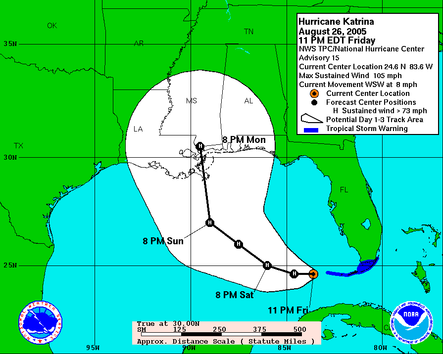
The Sum of All Fears: Historic Weather Event Unfolding
New Orleans Under the Gun
Jason Samenow @ 1:00 AM

Thanks, Howard, for that perspective. Additional information about the New Orleans hurricane threat is available at this Louisiana State University Center for the Study of Public Health Impacts of Hurricanes website.It's Saturday afternoon and Katrina is getting stronger and bigger and the National Hurricane Center is predicting that Katrina will slam into the Louisiana Coast as a Category 4 storm with winds of 140 mph and a storm surge of 18 - 22 feet. That would be very, very bad.
Let's go back in time. My first televison job was in New Orleans from 1989 - 1994. I was there when Hurricance Andrew made landfall about 60 miles SW of New Orleans. Close, but not a direct hit. I believe our strongest winds were around 60 mph.
New Orleans and southeast Louisiana have some unique problems with respect to tropical weather. The land is very flat and even more important, much of the land is below sea level. A massive canal and pumping system keep the water out of the city and surrounding areas. These pumps are amazing in the fact that they work so well. Yes, I have seen it flood when we get 14 inches of rain in 3 hours, but a 2 to 3 inch rain in a an hour from a thunderstorm can generally be handled with few if any problems.
With an approach of a tropical system from the south or south-southeast, on shore winds from the east and northeast will pile up water into Lake Pontchartrain. As the storm passes to the north, the winds will change to a northerly wind and push the high water along the levees that protect the city. Should any of those levees fail, all of that high water in the lake would inundate the city. According to computer models, that I remember from 10 years ago, some areas could have 10 - 20 feet of water.
With that much water a potential, where do you evacuate? I'm not up to date on recent plans, but there used to be talk of putting people into the taller buildings down town. Problem there is that as you go higher, the winds are even stronger and the tall buildings will likely lose wndows and suffer major damage as well. Evacuation is also more difficult to the limited number of escape routes. Interstate 10 is the main way out of southeast Louisiana. With limited routes, evacuations orders are given 50 hours before landfall. The storm is expected to hit on Monday, so they'll likely start today.
I also have been thinking about the price of gas. With a storm like this, Gulf of Mexico Oil Rigs are being evacuated. Less supply of crude, higher price for oil. Also, Plaquemines, and Jefferson parisheses have a few gasoline, oil and sulfur refineries, not to mention other parts of Louisiana. If they shut down, less gasoline, higher prices.
Kartrina, did do some damage in South Florida, but it has the potential to change Louisiana like no storm has since Hurricane Betsy in 1965.
Katrina is (at press time, 2am) a Category 4 storm (Category 5 at 11am) and has grown in size in addition to intensity (max winds at 175mph). Simply put, she's a montrous storm (when I look at the satellite image I'm reminded of the fake 'supercane' images that were used in the movie "The Day After Tomorrow"). She could (has) become a Cat 5 storm before making landfall.
Track guidance (see also this map) from the models has not shifted much from yesterday which is bad news. When models are consistent for run to run, it usually means they're onto something. The saving grace for New Orleans will be if it tracks east of the city, resulting in the maximum storm surge being a bit east of Louisiana delta.
I tend to think the center will move somewhat east of New Orleans--perhaps sparing the city from the worst case scenario, but the margin for error is so low, and the potential impact of any deviation in track so high, that I think efforts to pinpoint the exact landfall should be de-emphasized.
Mandatory evacuations are likely to commence this morning and contraflow (in which in-bound lanes become outbound) has been engaged. The New Orleans media is providing wall to wall coverage of this event. A comprehensive set of resources is available at WxNation's Wire. Here are a few of the key ones:
- New Orleans Times-Picayune
- New Orleans CBS Affiliate Live Coverage (Requires Windows Media Player)
- Hurricane Webcams
- Current satellite image
- New Orleans Radar
Our weather here in DC should improve throughout the day. Some morning showers are possible, with the possibility of the sun emerging during the afternoon. Expect high temperatuers in the low 80s.
Email this post
