

Thursday, February 02, 2006
10-Day Outlook: Winter Finally Returns!
Josh Larson @ 12:30 AM
Today's Forecast
Balmy weather is on tap today, with partly sunny skies and high temperatures near 55 in most locations. Clouds will be on the increase as the day wears on, ahead of an area of low pressure approaching from the south and west. Cloudy tonight, with scattered showers developing by dawn Friday; overnight lows will range from 40-45.
Pattern Overview
 The once-contentious and much-heralded "return to winter" will begin on February 5! However, we're not quite there yet... We'll see three more days of unseasonable warmth courtesy continued strong southwesterly flow aloft before a trough settles into the Northeast by Sunday and expands and strengthens through next week, bringing at least a week of below normal temperatures Feb 7 through Feb 14.
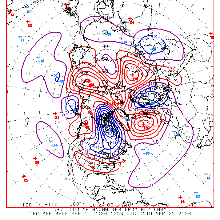
We've been talking about a return to winter for at least two weeks now, and it is now clear that all of the important atmospheric signals point to the return of cold (and potential for cold) to the eastern half of the US through at least mid-month. The Arctic Oscillation will become increasingly negative over the next two weeks; the PNA will become increasingly positive; high pressure/blocking will build over much of Canada. All of this will result in a very strong ridge-west/trough-east pattern establishing itself North America (see image above).
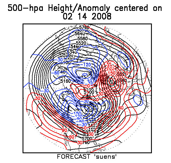
In short, by mid-February, we may be looking at near-record or record cold over some locations in the eastern third of the US (perhaps even including in our neck of the woods). CPC's super-ensemble model shows that by Feb 10 the flow over the eastern US will be straight out of the North Pole -- a situation some term the "Siberian Express" (see image above). In addition, there are some model indications that despite the sea of cold, a relatively active southern-branch storm track will persist; (I'm still not sold on this: the cold may be so strong as to possibly suppress storms to our south.) However, CPC's February outlook now calls for below normal temperatures for our region and above normal precipitation: Make no mistake, winter is back!
The next 5 days (Feb 2-6)
Forecast highs/lows: 51/35 (normal = 44/28)
Forecast precip: above normal
The following 5 days (Feb 7-11)
Forecast highs/lows: 40/24 (normal = 45/29)
Forecast precip: near normal
Snow Lover's Crystal Ball
Next Chance of Accumulating Snow: Sat into Sun, Feb 4-5
Probability: 25%
Potential Impact:
Commentary: Models diverge greatly as to how to handle the digging trough and resultant jet energy which may lead to an area of coastal low pressure developing late Saturday into Sunday. A track too far west (inland) will bring all rain; a track too far east (out to sea) will have little or no effect on our area; a track close to the coast will bring rain changing to snow, with measurable accumulations possible. Stay tuned to CapitalWeather, as this snow potential will come better into focus as we get closer to the event.
Comments are closed for this archived entry | Link |  Email this post
Email this post
