

Thursday, January 04, 2007
No End In Sight to Above Normal Temperatures
Josh Larson @ 8:00 AM
Expect much above normal temperatures to continue, relentlessly, over the next 10+ days, with mother nature still favoring more clouds than sun on most days. Showers are likely Friday into early Saturday and late Sunday into early Monday; but sandwiched in between -- Saturday afternoon -- we'll likely reach or exceed record highs across the area.
 Some sun; mild. Expect mostly sunny skies to start the day, though clouds will increase appreciably during the second half of the day. Even still, there should be enough sunshine that temperatures will reach the 60 degree mark area-wide. We'll have mostly cloudy skies overnight with mild lows in the upper 40s to low 50s.
 Showery + mild. Despite overcast skies and periods of showers, temperatures on Friday will climb to the lower 60s thanks to strong southerly winds. Expect a few sprinkles or stray showers Friday night with balmy lows near 55 -- more than 10 degrees above the average high temperature for this time of year.
Saturday: Shorts weather?! While morning clouds and a stray shower may linger into Saturday morning, we'll look for at least partly sunny skies by the afternoon. The amount of sunshine localities see will make the difference between near-record high temperatures in the mid and upper 60s and record temperatures in the low 70s; (I'd say we have a very good shot of exceeding IAD's record high of 66 and a 40% chance of at least tying DCA's record high of 72.)
 Sunday: Somewhat closer to normal.We'll look for partly sunny skies on Sunday with somewhat more 'rational' highs near 55 (still 10+ above normal). Clouds will increase late in the day ahead of the next area of low pressure which may bring showers or steadier rain to the area overnight Sunday into Monday morning; overnight lows will be cooler -- in the low to mid 40s.
Pattern Overview
 I still do not see any indications of a change away from above normal temperatures for our area over the next week to ten days. Much of North America is now clearly seeing many (though not all) of the impacts of a moderate El Nino. While it appears that high pressure may finally build over western Canada in the mid-term, it remains to be seen whether a negative NAO might develop that would finally bring seasonably cold air back to our region. That being said, there are definitely some indications that the current, overall atmospheric pattern over North America may be beginning to shift, so I caution that computer model (as well as human) forecasts out past a week will have a particularly tough time accurately picking up on the details of the progression of the overall weather pattern.
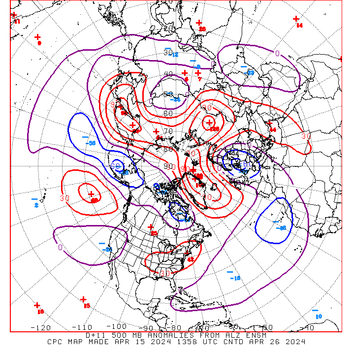
Pictured above: A "D + 11" forecast -- centered 11 days from now -- from one of CPC's Superensemble forecast models shows positive atmospheric height anomalies in red and negative anomalies in blue; if this solution were to verify, we'd expect above normal temperatures for our area to continue into the middle of the month.
Next week's forecast
Forecast highs/lows: 52/37 (normal = 42/27)
Forecast precip: Near normal
 Expect mostly cloudy skies on Monday morning with lingering showers possible; we'll see some partial clearing later in the day with highs in the low 50s and overnight lows in the low to mid 30s. Tuesday will feature partly sunny skies with cooler, near-climatological highs in the mid and upper 40s and lows in the mid 20s to low 30s. Somewhat milder again on Wednesday with times of clouds and sun with highs near 50 with overnight lows near 32. We'll look for cloudy skies with a chance for showers on Thursday with highs near 50. From this vantage point, Friday looks partly sunny and dry with highs likely in the upper 40s to low 50s with lows in the mid to upper 30s.
An article I've written, titled "The Emergence of the Weather Blog" appears in the January-February edition of Weatherwise Magazine. In it, I chart the development of the weather blog as a medium and profile a number of different sites, including CapitalWeather.com. Check it out here.
Today
Tomorrow
LARSON'S LONG-RANGE
Pattern Overview
 I still do not see any indications of a change away from above normal temperatures for our area over the next week to ten days. Much of North America is now clearly seeing many (though not all) of the impacts of a moderate El Nino. While it appears that high pressure may finally build over western Canada in the mid-term, it remains to be seen whether a negative NAO might develop that would finally bring seasonably cold air back to our region. That being said, there are definitely some indications that the current, overall atmospheric pattern over North America may be beginning to shift, so I caution that computer model (as well as human) forecasts out past a week will have a particularly tough time accurately picking up on the details of the progression of the overall weather pattern.
Pictured above: A "D + 11" forecast -- centered 11 days from now -- from one of CPC's Superensemble forecast models shows positive atmospheric height anomalies in red and negative anomalies in blue; if this solution were to verify, we'd expect above normal temperatures for our area to continue into the middle of the month.
Next week's forecast
Forecast highs/lows: 52/37 (normal = 42/27)
Forecast precip: Near normal
Shameless promotion?
An article I've written, titled "The Emergence of the Weather Blog" appears in the January-February edition of Weatherwise Magazine. In it, I chart the development of the weather blog as a medium and profile a number of different sites, including CapitalWeather.com. Check it out here.
Comments are closed for this archived entry | Link |  Email this post
Email this post
