

Wednesday, August 15, 2007
Different Week, Same Story
Midweek heat wave gives way to weekend comfort
Dan Stillman @ 8:30 AM
Just like last week, we'll see hot midweek conditions transition to a cooler, comfortable weekend. This time, the heat won't be quite as hot, and the weekend will be cooler than the last. Rain chances remain slim, with the exception of Thursday PM into Friday AM.
 Hot, not too humid. The heat is back in full force, but the humidity will remain in check, although it won't be as dry as yesterday. Skies should be partly to mostly sunny with highs in the mid 90s. Winds will be light at 5-10 mph. Tonight, partly cloudy and turning more humid. Lows in the low-to-mid 70s in town, mid-to-upper 60s in the burbs.

 Hot, more humid ... any rain? Under partly sunny skies, highs should once again soar to the mid 90s, but with more humidity than today. The afternoon heat index is likely to reach near 100. The breeze should pick up in the afternoon ahead of an approaching cold front, which could generate isolated showers or thunderstorms during the afternoon or evening (30% chance). A few storms could be strong or severe. Overnight, partly to mostly cloudy with a 30% chance of showers and some strong or severe storms. Lows in the low-to-mid 70s in town, near 70 in the burbs.
Pictured: Clear skies cover the Mall on Saturday. By CapitalWeather.com photographer Ian Livingston.
 Warm, breezy, AM shower/storm. Look for partly cloudy skies in the morning as the cold front comes through with a chance of a lingering AM shower or storm. Then, behind the front, becoming partly to mostly sunny and breezy in the afternoon with falling humidity and highs in the upper 80s to near 90. Overnight, mostly clear and cooler. Lows in the mid 60s in town, upper 50s to near 60 in the burbs.
Comfortably warm. As of now, the weekend is shaping up to be a real gem. With high pressure in control, Saturday should be sunny with low humidity and highs near 80. Saturday night, partly cloudy and cool with lows in the low 60s in town, mid-to-upper 50s in the burbs. On Sunday, it looks favorable for high pressure to hold on and provide partly to mostly sunny skies, low humidity and highs in the low-to-mid 80s. However, we do need to keep our eye on some moisture to the south. As such, I'm not ready to guarantee that shower chances won't creep into the Sunday forecast.
The tropics are starting to get active:
We already know the devastating effects ongoing drought has had on area farmers. But what impacts -- beyond browning gardens and higher food prices at the grocery store -- could be in store for the population at large should the drought continue or get worse?
The greater DC area is currently in the midst of a "severe" drought, which falls in the middle of the categories used by the U.S. Drought Monitor. From least serious to most serious, the five categories are: Abnormally Dry, Moderate, Severe, Extreme and Exceptional. Although the current drought has prompted some water restrictions in outlying Maryland and Virginia locations, it has yet to trigger widespread mandatory restrictions. In Birmingham, Ala., where drought has reached "exceptional" levels, outside watering hours were restricted to a 5-hour period on rotating days, and a ban was placed on car washes that don't recycle water, though the restrictions were later relaxed.
A 2002 Washington Post article by climatologist Pat Michaels suggests that one of the biggest impacts from the most severe of droughts is the potential for hot summer days to be even hotter (because with less moisture, more of the sun's energy goes into heating the ground rather than evaporating water). As an example, yesterday was Birmingham's eighth consecutive day with temperatures 100 degrees or warmer, tying the record set in 1980. In 1930, during the worst drought on record for the DC area, shade temperatures of 107 (July 19), 109 (July 27) and 110 (Aug. 3) were recorded by a downtown thermometer maintained by the Washington Post, according to the article. Michaels goes on to predict that if a drought of similar magnitude and geographic coverage occurred today:
"D.C. would be much hotter. The city is much larger than it was, and airflow is even more impeded. Conservatively estimating, urban core temperatures would probably reach around 113. ... It is impossible to predict exactly how many deaths would result. If the power stayed on, research by my University of Virginia colleague Robert Davis and myself suggests maybe 50 to 100. But it's not at all clear that the air conditioners would continue to run. ... Soon after the power goes out, deaths begin. We know this from the Chicago heat wave of July 1995, when, a thundershower caused a major outage. About 500 died."
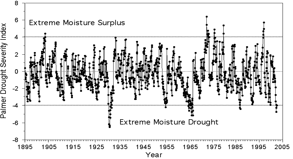
The good news is that, for the time being at least, the severity of the current drought is a long way from 1930 levels. The latest forecast for the Palmer Drought Severity Index, which combines temperature and rainfall information to determine dryness, puts the metro area at -3 to -3.9, still far from the extreme of below -6 in the early 1930s. And the forecast from the Climate Prediction Center is somewhat encouraging: "Hot, dry weather in early August will cause drought to worsen from Maryland and Virginia into North Carolina, but the odds favor increased rainfall later in the season, resulting in overall improvement by October."
The remnants of just one juicy tropical system passing through during the next couple of months could go a long way toward alleviating concerns of a more extended and serious drought. However, should drought conditions worsen during the fall, winter and spring, then next summer could make our recent heat wave pale in comparison.
Today
Tomorrow
Pictured: Clear skies cover the Mall on Saturday. By CapitalWeather.com photographer Ian Livingston.
Friday
The Weekend
Tropical Update
The tropics are starting to get active:
- Tropical Storm Dean is expected to gradually strengthen into the first Atlantic hurricane of the season. The storm could track near or south of Puerto Rico and the Dominican Republic over the weekend. From there, its track is quite uncertain, but a hit on the U.S. mainland is a possibility next week.
- In the Pacific, Hurricane Flossie has been tracking to the south of Hawaii with, as of last night, maximum sustained winds of 100 mph (Category 2) and higher gusts. Heavy rain, tropical storm force winds and heavy surf were expected in Hawaii yesterday night and today.
- In the Gulf of Mexico, a disturbance was declared Tropical Depression Five yesterday night. It could become Tropical Storm Erin today as it tracks toward south Texas, possibly making landfall tomorrow.
What if Drought Gets Worse?
We already know the devastating effects ongoing drought has had on area farmers. But what impacts -- beyond browning gardens and higher food prices at the grocery store -- could be in store for the population at large should the drought continue or get worse?
The greater DC area is currently in the midst of a "severe" drought, which falls in the middle of the categories used by the U.S. Drought Monitor. From least serious to most serious, the five categories are: Abnormally Dry, Moderate, Severe, Extreme and Exceptional. Although the current drought has prompted some water restrictions in outlying Maryland and Virginia locations, it has yet to trigger widespread mandatory restrictions. In Birmingham, Ala., where drought has reached "exceptional" levels, outside watering hours were restricted to a 5-hour period on rotating days, and a ban was placed on car washes that don't recycle water, though the restrictions were later relaxed.
A 2002 Washington Post article by climatologist Pat Michaels suggests that one of the biggest impacts from the most severe of droughts is the potential for hot summer days to be even hotter (because with less moisture, more of the sun's energy goes into heating the ground rather than evaporating water). As an example, yesterday was Birmingham's eighth consecutive day with temperatures 100 degrees or warmer, tying the record set in 1980. In 1930, during the worst drought on record for the DC area, shade temperatures of 107 (July 19), 109 (July 27) and 110 (Aug. 3) were recorded by a downtown thermometer maintained by the Washington Post, according to the article. Michaels goes on to predict that if a drought of similar magnitude and geographic coverage occurred today:
"D.C. would be much hotter. The city is much larger than it was, and airflow is even more impeded. Conservatively estimating, urban core temperatures would probably reach around 113. ... It is impossible to predict exactly how many deaths would result. If the power stayed on, research by my University of Virginia colleague Robert Davis and myself suggests maybe 50 to 100. But it's not at all clear that the air conditioners would continue to run. ... Soon after the power goes out, deaths begin. We know this from the Chicago heat wave of July 1995, when, a thundershower caused a major outage. About 500 died."
The good news is that, for the time being at least, the severity of the current drought is a long way from 1930 levels. The latest forecast for the Palmer Drought Severity Index, which combines temperature and rainfall information to determine dryness, puts the metro area at -3 to -3.9, still far from the extreme of below -6 in the early 1930s. And the forecast from the Climate Prediction Center is somewhat encouraging: "Hot, dry weather in early August will cause drought to worsen from Maryland and Virginia into North Carolina, but the odds favor increased rainfall later in the season, resulting in overall improvement by October."
The remnants of just one juicy tropical system passing through during the next couple of months could go a long way toward alleviating concerns of a more extended and serious drought. However, should drought conditions worsen during the fall, winter and spring, then next summer could make our recent heat wave pale in comparison.
Comments are closed for this archived entry | Link |  Email this post
Email this post
